VOLCANOES AND CONTINENT COLLISIONS IN TARRAS VALLEY NATURE RESERVE!

VOLCANOES AND CONTINENT COLLISIONS IN TARRAS VALLEY NATURE RESERVE!
The remote moorland of Tarras valley nature reserve has not always been the same as we see it now. About 430 million years ago (MA) the area was part of a massive collision zone between Scotland and England when two continents collided to form Himalayan scale mountains – the collision suture lying approximately along the current Scotland-England border!
The region was later volcanically active with erupting volcanoes and lavas flowing over the land. An exciting past revealed by the rocks exposed today!
As a result the reserve area is very important geologically, both nationally and also worldwide – hence it is an SSSI and a registered geosite on the BGS (British Geological Survey) and Scottish Geological Trust online databases.
On the west of the reserve are outcrops of steeply dipping Silurian greywackes (c 430 MA) – poorly sorted sandstones deposited as turbulent submarine fans at the edge of a continent bordering the ancient Iapetus ocean. This huge ocean, similar in size to our current day Atlantic ocean, separated Scotland from England around 500 million years ago.
The movement of huge tectonic plates gradually closed the Iapetus ocean (470-420 MA) moving England from near the south pole to collide further north with Scotland.
The gigantic continental collision resulted in a huge mountain chain further north (the Scottish Highlands) while the greywacke sandstones (at the trailing edge of the collision) were squeezed up to form the steeply dipping beds we see today (as now exposed at Sorbie Crags and Monument quarry).
The mountains of the Scottish Highlands further north and the Southern Uplands, containing the Tarras Valley nature reserve, were eroded down by turbulent rivers (as in the Himalayas today) so, by early Carboniferous times (350 MA), the hills in the Tarras area were similar in height to today but the climate was much hotter and arid, as our area had moved north to the equator.
Around 359-345 million years ago tectonic plate movement resulted in pulling apart and sagging of the crust along the old Iapetus suture (a zone of weakness) leading to formation of the Northumberland-Solway sedimentary basin which covers part of the Tarras reserve. This basin is renown for demonstrating how a sedimentary basin originates and evolves, how sediments (sandstones, limestones etc) infill the basin and how volcanic eruptions are related to basin evolution. Pulling apart of the crust led to magma rising up from depths of many kilometres, eruption of numerous volcanoes and extrusion of lava flows across the land surface
(as seen today at Arkleton crags, Roan Fell and in the River Esk bed at Skippers bridge).
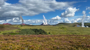
Across the Langholm area and the Borders there are 40-50 eroded remains of volcanoes, now represented by subvolcanic plugs and vents, infilled with fragmented rock, which once fed the overlying lava flows. Erosion of some 1 kilometre of overlying lava flows means that we now only see the roots of these ancient volcanoes and isolated lava outcrops across the reserve and further north, east and west. The volcanoes were scattered every few kilometres and formed cones with heights of several hundred metres, amidst a semi arid landscape traversed by seasonal rivers with ferns and vegetative cover. Intervals between volcanic eruptions were probably tens or hundreds of years. We can now see interbedded sandstones within the lavas showing that overflowing rivers spread sediment across the lavas – similar to rivers today in volcanically active Iceland. Similar volcanic plugs exist to the north of the reserve – Ruberslaw hill and Minto hills. As the basalt lava is more resistant than the sediments it tends to form resistant crags and hills, such as Arkleton Crags, Roan Fell, and Watch Hill in the Tarras reserve.
The Tarras valley volcanic activity did not develop into the huge volcanic complexes further north in the Hebrides, of which the remnants are seen today on Skye, Mull, Rum, Arran, Ardnamurchan and St Kilda – these were active much later, around 60 million years ago, and are related to the opening up and formation of the Atlantic ocean.
The volcanism over the Tarras area moved north with time towards Teviothead, Melrose and Edinburgh (Arthur’s Seat) – all related to the same crustal extension and basin evolution.
Many volcanic vents (still infilled with solidified ash and agglomerate thrown out by the volcano) and lava flows intermittently outcrop across the Borders and Lothian region north of the Tarras reserve.
In late Carboniferous times (320-300 MA) thick river sandstones were laid down over the volcanic rocks (white sandstones of Whita Hill) with lagoonal limestones and mudstones, the climate becoming more tropical and humid. By Permian times (290 MA) we were experiencing hot desert conditions, resulting in massive red sand dune deposits – as seen along the banks of the river Esk in Canonbie. A great supercontinent called Pangea had formed by the movement and joining together of the continents at the end of the Carboniferous (300 MA) and Scotland lay within the middle of this huge continent in the Permian and later Triassic periods. The Scottish highlands formed higher ground to the north as rocky upland deserts, while vast sand deserts lay over south Scotland, similar to the Sahara desert today.
No further later rocks were deposited over the Tarras valley reserve until glacial deposits of the Ice Age (around 2 MA) were deposited as boulder clays and alluvium in river valleys. The final glaciers melted here around 13,000 years ago.
What we can see from the rocks today, which geologists can piece together like a detective story from detailed mapping and measurement, reveals a fascinating 500 million years of geological history of how the land of the Tarras valley nature reserve exists today.
Dr Linda Cotterill